

LIFJELL
PRIVATE HIKE
Short summary
Lifjell is one of the finest viewpoints in northern Jæren, offering breathtaking panoramas of Gandsfjorden, the North Sea, the region’s major cities, and the stunning landscapes of Ryfylke.
This hike blends diverse experiences, from strolling along the charming shoreline of Bjorhamn to following cairns across ice-scoured bedrock at 287 meters above sea level.
The trail begins and ends in dense coniferous forests, while the slopes along Gandsfjorden come alive with birdsong in the rich and occasionally dense mixed woodlands.
HIKERS:
Max 4 persons
Minimum age: 10
DURATION:
Minimum:
6 hours
LENGTH:
Approximately:
9 km
DIFFICULTY:
 |  |  |
|---|---|---|
 |  |  |
 |  |  |
 |  |  |
 |  |
Hike Description
About 40 minutes from the pick-up point, we arrive at Dale, a former mental hospital, where we park and prepare for the hike. Before setting off, we conduct an equipment check and a brief safety briefing covering trail details, expected conditions, and essential hiking tips.
Proper footwear is crucial, as the terrain varies between soft forest paths, wet areas, and rugged bedrock.
The journey begins through towering coniferous forests along the sea before the landscape opens up. Along Gandsfjorden, some sections can be slippery, but mounted wires provide assistance on the steepest parts.

This hike offers a unique blend of coastal and mountain terrain—you’ll wade along the shoreline in the picturesque Bjorhamn and follow cairns across ice-polished bedrock at 287 meters above sea level.
The first and final stretches lead through lush, mixed woodlands, where birdsong fills the air. As we ascend, the expansive views of Gandsfjorden, the North Sea, and Ryfylke unfold, making this one of the best vantage points in northern Jæren.

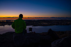
After a demanding trek filled with ascents, descents, and a bit of climbing, we reach the summit. From here, a breathtaking panorama unfolds, encompassing the entire Stavanger Peninsula. On clear days, you can see as far as Karmøy, large parts of Ryfylke, and down to Jæren. Looking in the opposite direction, you'll spot Hommersåk and the route toward Høgsfjorden.
At the top, a towering mast transmits TV signals, while the true summit is marked by an impressively built cairn just beyond. Here, we take a well-earned break, light a fire, and enjoy a warm drink and meal, all while capturing the moment with stunning photos.

The return journey is far easier, with a swift descent from the summit to the edge of Øksendalen over bare rock and a well-trodden path. A final push takes us up the slope between Flatafjellet and Sørafjellet— shorter and less steep than the initial ascent but still requiring some effort.
From the pass, the route is mostly downhill, leading first to Dalevatn, where a few steep sections await, before continuing toward Dale. The descent follows a well-marked trail and eventually a road, guiding us back to the car.

Organisasjonsnummer: NO 832 127 922
Email: stavangeradventure@gmail.com
© 2023 - ALL RIGHTS RESERVED